About

Tracks of the NYC Subway has been published continuously since 1997, and is now released yearly. It’s a 202-page spiral bound book depicting the entire track and station network of the NYC subway system. It consists of 57 main map pages that show how tracks and lines interact and shows the placements of stations, tracks and signals along with some to-scale details of more complex interlockings. There are also about 20 pages of to-scale yard track maps and details, as well as rolling stock fleet details.
In addition to the NYC Subway system tracks, it also encompasses tracks of the Long Island Rail Road, including Grand Central Madison, Penn Station, and Jamaica, along with the service and MoW facilities at Hillside and Holban Yards, the Advance, Receiving Yards, Sheridan Shops, and the Morris Park Yard.
The book further delves into the underground portions of the PATH network, the JFK AirTrain, and the former elevated networks in Manhattan, the Bronx, and Brooklyn.
There’s also a 45 page introduction that contains details on how the signaling systems work, both conventional and the new CBTC system that’s being expanded throughout the network, along with signs and signal definitions.
The PDF version is interactive, allowing the reader to easily jump throughout the book from the line maps to detailed inset maps or yard diagrams (and back again), and to external Internet links.
The book also includes details on abandoned tracks and stations, radio frequencies, whistle and buzzer codes and many other useful goodies. It's a must for any serious subway buff, railfan or straphanger who loves to know about the operations of the world's largest subway system.
WHAT’S IN THE BOOK
Here are four sample pages that represent how the information is displayed.
Click on the images to view PDFs for details.
Two typical map pages, arranged vertically for the Bronx and Manhattan, and horizontally for Queens and Brooklyn. There are 57 of these map pages in the book. These maps are not to scale, however they do show correlation between adjacent lines, rights-of-way, diverging route home signals and other important line features.


Interlocking closeups: This page is a typical example of a close-up map page. Its view is closer to scale than normal map pages and it shows diverging route home signals.
Maps like this also show the commonly-used routings for each route.
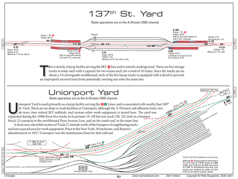
Closeup detail of the IRT 137th St. and Unionport Yards. This page is typical of the mostly-to-scale yard maps, providing a description of the yard, the services it provides, the class(es) of cars it services and a short description of the routes it serves.